Saeedeh Eskandari,
Jafar Oladi Ghadikolaei, Hamid Jalilvand, and Mohammad Reza Saradjian
Summary:
This article uses a combination of different techniques to assess
the risk of forest fires in District Three of Neka-Zalemround Forests in Northern
Iran. The study uses a fire risk model
integrated with the MCDM method in a GIS framework to map forest fire
risk. The authors claim that while there
have been many fire risk models to incorporate GIS, none have used the MCDM
method. The model developed in the paper
will be tested against the historical occurrences of wildfires in order to test
its reliability.
The area under examination is in the Mazandaran Province in
Iran, and covers an area of 153.07 km2. The minimum altitude is 90 m above sea level,
while the maximum is 820 m. This is an
area that has seen numerous wildfires in recent years.

The methodology being utilized consisted of four different
components:
- Determination of fire risk major criteria and sub-criteria and preparation of the maps
- Assignment of in-layer and out-layer weights to sub-criteria in a GIS environment
- Combination of sub-criteria and major criteria maps and construction of fire potential map
- Validation of the fire risk potential map
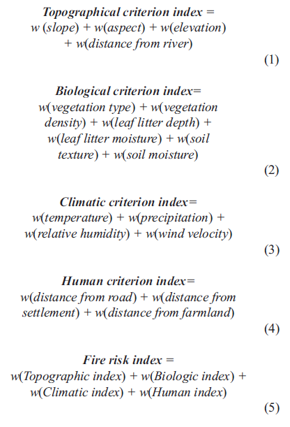
This study is using four major criteria (topographic,
biologic, climatic, and human), which are made up of a total of 17
sub-criteria.

Each sub criteria is modeled as a layer in GIS using raster
format. The in-layer weights of the
sub-criteria range from 0 to 1, with 0 being very low and 1 being very
high. The out-layer weights are the four
major criteria. The weights of the
sub-criteria add up to be the weight of the major criteria. In turn all of the major criteria are
utilized in calculating the fire risk index.
This is shown below, where w
indicated weight.
The maps were developed by using GIS spatial analysis and
the raster calculator option in GIS. The
individual cells of the fire risk potential map have been ranked from very low
to very high based on these calculations.


When the fire risk potential map is compared to the map of actual
fires the model holds up favorably. This
indicates that the multi-criteria model they used has a good efficiency to
predict future fires. If it were to be
used in other areas however, the weights would need to be changed accordingly.


Critique:
This is a well laid out and carefully written article. It does a great job explaining exactly what
the authors did without being overly complicated. My greatest concern involves the MCDM aspect
of the study. While their results were shown
to have a strong correlation with real life fires, this is due to their
criteria being properly weighted. From
what was in the article it seems like this would be difficult for someone
without both a deep knowledge of the area and a talent for weighting that
knowledge to replicate.
Source:
Eskandari, S., Ghadikolaei, J. O., Jalilvand,
H., & Saradjian, M. R. (2015). Prediction of Future Forest Fires Using the
MCDM Method. Polish Journal Of Environmental Studies, 24(5), 2309-2314. http://eds.a.ebscohost.com/eds/detail/detail?sid=3623cd0a-2492-425c-885b-fb64d206c48d%40sessionmgr4004&crlhashurl=login.aspx%253fdirect%253dtrue%2526profile%253dehost%2526scope%253dsite%2526authtype%253dcrawler%2526jrnl%253d12301485%2526AN%253d109426727&hid=4113&vid=0&bdata=JnNpdGU9ZWRzLWxpdmU%3d#AN=109426727&db=a9h


In your critique, are you stating that MCDM is more effective when conducted with people with deep knowledge? With that said, do you believe MCDM would be subject to a significant amount of group think?
ReplyDeleteBased on how this group conducted the technique it apprears that they really only used their personal experiance to weight the criteria. Following this model it would require a degree of knowledge past what the average person has in order to weigh it properly. Yes I could see this opening you up to the potential of group think.
DeleteDan, I agree with your critique. As we both know, humans are very poor at accurately weighing variables, and while this specific example would be difficult for a non-expert to duplicate, I think their process could be duplicated without much difficulty for other issues.
ReplyDeleteDan, this is really a good example of MCDM implementation. I am curious to learn how did they weight variables. Does it solely depend on personal expertise or anything else?
ReplyDeleteIt apprears as though they weighted the variables solely with personal experiance, I feel like this is one of their major weaknesses.
DeleteAt the comparison level of the maps, the study seems fancy. However, as far as I see they have already mapped as high risk area almost all north side of the area. And, since the actual fires occurred at those areas it seems to us that it overlaps almost perfect. Here my concern comes in. Since MCDM is utilized in determining best option, I am not sure that this method worked in mapping the fire risk. Because, if policy makers would take precautions according to the map the authors prepared then they would have to deploy fire fighter units all around the north side. However, yes fire took place at north but not all around the north, this wouldn't be cost effective. Therefore, they must make it more clear that how did they utilize MCDM in their study.
ReplyDeleteI really liked this example because it incorporated GIS with MCDM. Also, I do agree with you that weighting variables based on personal experience alone is a major weakness.
ReplyDeleteI really liked this example because it incorporated GIS with MCDM. Also, I do agree with you that weighting variables based on personal experience alone is a major weakness.
ReplyDelete